
Walks near Water
We all like walks near water! When choosing a walk or ramble we realise that we often select a route that is near to water, be it the sea, an estuary, a canal or river walk, a walk around a reservoir or behind a waterfall. All of these are within an easy driving distance. Without ever having considered this before, possibly the water adds calmness or tranquility and an opportunity to observe the changing seasons.
There are many walking opportunities that come to mind from a local stroll to more challenging terrain or distance, however here are some pointers.
A Canal Walk
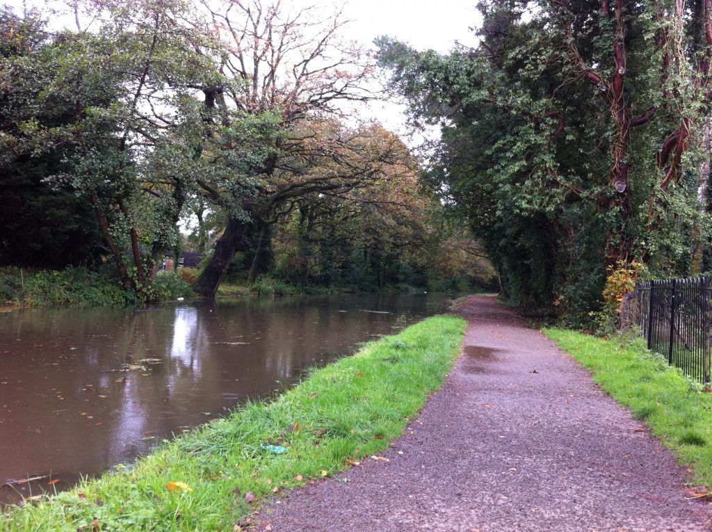
The Swansea valley Canal
We are fortunate to have several canals within a relatively short distance or they can be made into or incorporated into a day trip to give another walks near water, Locally, from Pontardawe (just 2 miles away, downhill) from the cottage is a popular walk along the Swansea valley canal down the valley to the far end of Clydach. Should you not wish to walk back uphill to the cottages at the end of the day, then you can either park in Pontardawe to give a 3 mile walk each direction or park up the valley at Cilmaengwyn or Godregraig and join the canal path from its starting point, thus adding an additional two and a half miles to the route. On average each stage would take probably take an hour each, but personally we would aim to reach the Mond Nickel Works on our nearside of Clydach and detour up to Fadre Road to the Pantri cafe for a highly recommended lunch or coffee stop (and cake too of course!), possibly in good weather then a take away packed lunch?
Four miles away is Neath, having there a choice of two canals, built to reach 2 different port destinations. Although the Neath and the Tennant canals are independent of each other, they are often linked confusingly together in reference as the Neath & Tennant Canal. The Neath Canal runs just over 12 miles from Glyn Neath to the once port south of Neath, now referred to as Giants Grave near Britton Ferry. The Tennant Canal runs from Aberdulais, just north of Neath down to Swansea, a distance of 8 miles. Both canals touch on Aberdulais, where the Tennant Canal crosses the River Neath by means of a spectacular 12 arch aquaduct at Aberdulais.
The full length of the canal is just over 12 miles, the Sustrans route 46 and 47 also share this route from Briton Ferry to Glyn Neath. If a short option is required then Aberdulais is a good starting point. It is generally easy to park in a long lay by near to the Aberdulais Tin Works and Falls, a National Trust site of interest which has a few simple facilities, coffee, toilets, tourist info and gifts. This was once a site of industry and the info gleaned there would assist in the understanding of the area and of the need for transportation and the importance of these respective waterways to the industries of the Neath valley.
Aberdulais is a convenient meeting point for the 2 waterways and possibly if having walked from Neath on the Tennant canal, here is an opportunity to cross over to the Neath canal and walk up towards Glyn Neath (8 miles away), or return down to Neath on the Neath canal.
Resolven could be another starting point as it has easy parking and is at mid point approx of 5-6 miles from both Aberdulais and Glyn Neath.
In a very small area of Aberdulais, there are seemingly more bridges than any other similar size area in the UK! This has always had a convergence of routes, river, roads, and the 2 canals are all very near, then add the railway bridge over the river and the 130 metre aquaduct carrying the Tennant canal over the river. In addition, within the Nat Trust site are the remains of a tram bridge and at the Aberdulais Basin is the Pont Gam, which translates as the crooked bridge or Skew Bridge. The latest addition to the centuries of bridges is the modern bridge network created to carry the fast A465 dual carriageway down the Neath valley that serves as a route to connect the Midlands to Neath and Swansea.
When choosing which part of the canal to walk, do consider that just under 2 miles from Resolven or over 4 miles from Aberdulais is Melin Court Waterfall. This is a short uphill climb from the roadside, it is a detour from the canalside, but a convenient way to add some waterfall interest, though best reached by car on the way home.
Aberdulais to Neath is a distance of only 2 miles, but I have always enjoyed this section, consider the easy parking at Aberdulais, then walk down the Neath canal to Neath, passing the many bridges, take note of the canal side terrace of houses. Eventually with the road network behind you, the canal path opens into countryside and across the water is the ancient church of St. Illtyd’s. As you approach Neath, the envy sets in as you realise that what had always been seen as roadside cottages and houses, actually have gardens that back down onto the canal. There are several low bridges to pass under, sometimes creative graffiti to be admired, the Quaker House and Neath Castle being near enough for a quick visit. It is easy to find a cafe with character, Moruzzi’s is very near to Morrison’s and worth asking for the easy directions. Consider returning onto the far end of Bridge Street and join the Tennant canal to walk back to Aberdulais.
This canal runs a total of about 9 miles from Aberdulais down to Port Tennant on the east side Swansea. If a shorter taster walk is wanted, with added interest, then park at Neath Abbey ( behind the Tesco Store at the Neath Abbey / Neath roundabout, near to the M4 exit sliproad roundabout. Parking there is free and the Neath Abbey ruins will probably impress sufficiently to spend some time there – before or after a canal walk. It is 3.5 miles from the Abbey to Aberdulais.
After a mile the canal crosses the edge of Bridge St in Neath town centre. It is worth walking onto the old Neath river Bridge to look North. Note the proximity of the Tennant canal on the left side, near the freight branch railway, then the wide tidal Neath river and to its right is the Neath Canal
South of neath Abbey, the canal passes through a far more rural and tranquil area. The canal travels through Pant y Sais Nature Reserve and then onto Crymlyn Bog to the west. This is a very large lowland fen with extensive reed beds, it is a haven for wetland plants, birds and insects.
A Riverside Walk
A further opportunity for walks near water. Virtually on our doorstep, just under a 2 mile walk down the hill to Pontardawe from the cottages is the Sustrans cycle route https://www.sustrans.org.uk/find-a-route-on-the-national-cycle-network/route-43, once the railway line from Swansea via Pontardawe and up to Ystalyfera and Ystradgynlais.
Whilst the route stretches some 17 miles in total from Swansea up the valley via Pontardawe, from Pontardawe northwards, it is also very popular with walkers with the route bordering on the Tawe river for much of it. The railway line was at the base of the steep side of the valley, but after the demise of the railway and the fires that the steam trains sometimes caused on the embankments had ceased, the valley sides have once again have become green, lush areas. Therefore after many decades of regrowth, the valley floor is quite shaded with now large trees with mature overhanging branches. Shady is Summer and colourful as Autumn descends.
The walk up to Godrergraig is just over 3 miles, there is a car park there and a bridge crossing the river to the pathway. Below the bridge is a weir where in for a short time in the Autumn, the salmon can be seen jumping up the weir and river to spawn. the path continues further up the valley to Ystalyfera and beyond to Ystradgynlais, though after Ystalyfera, the path is a little more indirect. Ystalyfera is a further mile and Ystradgynlais over 6 miles from Pontardawe.
If a shorter walk is wanted , then stop at Godregraig, cross the river, car park and the main road, then in a few yards it is possible to join the canal path back down to Pontardawe, a round trip of 6 miles to Pontardawe, almost 10 miles if the cottages are the starting point.
Lliw Reservoir https://www.swansea.gov.uk/lliwreservoirs
Walks near water include walking around a reservoir! Just 10 – 12 miles away are Lliw Reservoirs, depending on your choice of route – there is the major A4067 down the valley to the large Ynysforgan roundabout then a journey of just 1 junction on the M4takes you then to a country road to Felindre. An alternate route can be taken down the old B4603, it is shorter by a few miles but a little slower. In Clydach take the mountain road that links the villages of Clydach to Graig Cefn Parc, passing the reservoir before reaching the village of Felindre.
This is an area of wilderness on the edge of the county of Swansea. However unlike many cities, Swansea has so many areas of coastal and rural beauty that this area remains quiet and seems remote to most Swansea city residents.
There are 2 reservoirs, the easily accessed Lower Lliw Reservoir where the car park, cafe and toilets are located. From there is a 4 mile push / chair accessible route. There is a popular 2 mile walk to the Upper Lliw reservoir which is part of the Gower Way.
A Promenade Walk
The ultimate of walks near water, walking on the beach. Oh to have a seaside walk – often the cry of guests, especially those who do not live near the coast.
From Swansea Marina, it is possible to walk around the 8 miles of Swansea Bay. It is all flat and a tarmac surface and a very popular walking route., the path being next to the beach or lapping sea depending on the tidal times. The path is shared with cyclists, with a line in the centre defining each ones space. Some of the areas, especially down in Mumbles get quite busy at certain times, where people take a shorter stroll to a cafe. This is a lovely area to see, depending on the time of day and the season it can be not the most relaxing walk with young children, buggies, bikes and differing walking paces to contend with, nevertheless very worthwhile to visit. Walks near water.
Coastal Path Walk
Wales has a continuous pathway around the full coastline. From Tan yr Eglwys cottages, the most appealing coastal aspect has to be around the Gower Peninsula walks near water!.
To have a change away from the flat promenade walk around Swansea Bay, have a clifftop walk with sea views. Park over beyond Mumbles around at Bracelet Bay where there is a large car park. Then follow the undulating coastal path around to Langland then Caswell and beyond. There are a few nice cafes to aim for en route. Bracelet Bay to Langland is 1.7 miles and Langland on to Caswell is a further 1.3 miles.
Cardiff Bay is easily reached by car , an hour’s journey out with the main commuting times. Equally the mainline rail network goes from Neath to Cardiff Central in 50 minutes and then you can either catch a local train or walk the mile down to the Bay. (Both oddly are 19 minutes of a journey)
Cardiff Bay is interesting to walk around and reflect on the many changes that have occurred over recent decades again a walks near water. The Tiger Bay of the past has been redeveloped and now unrecognisable as the large port that transported coal throughout the world. However a few pointers remain and sit amidst the renovated and modern eclectic eye catching buildings, it is certainly worth exploring.
The Pierhead Building with its distinctive red sandstone is part of the Marquis of Bute’s Scottish legacy, now part of the Sennedd. the Coal Exchange building is impressive and another historical connection.
Added to this mix, down at the Oval Basin, once the gateway into Cardiff Docks and filled in during the 1960’s, there are the modern Water Towers, the Wales Millenium Centre and the Senedd Building. The latter is certainly an interesting place to visit, once bags are searched you are allowed to enter for a coffee or to observe the government meetings in action.
The Norwegian Church can be aimed for, a wooden church building where Roald Dahl was christened. Various art works and sculptures are dotted about the Bay, a reminder of the history of the area.
Once beyond the Norwegian Church and continue on a route known as the Cardiff Bay Trail, it crosses over the barrage to Penarth. The barrage was built during the 90’s to contain the water from the Ely and Taff rivers thus creating a huge freshwater lake to replace the tidal mudflats. The Barrage is a mile and a half in length, can be walked or cycled, but there are water buses travelling between Penarth and Cardiff Bay.
A Waterfall Walk.
There are several waterfall walks a short car ride from Tan yr Eglwys cottages. Do refer to a blog we have written on the subject for more details. https://www.walescottagebreaks.co.uk/category/location/waterfalls/
There are also some waterfalls that can be reached on foot from the cottages. These are for the more experienced walkers as the paths are not well defined and on rough terrain, good map reading skills are required.