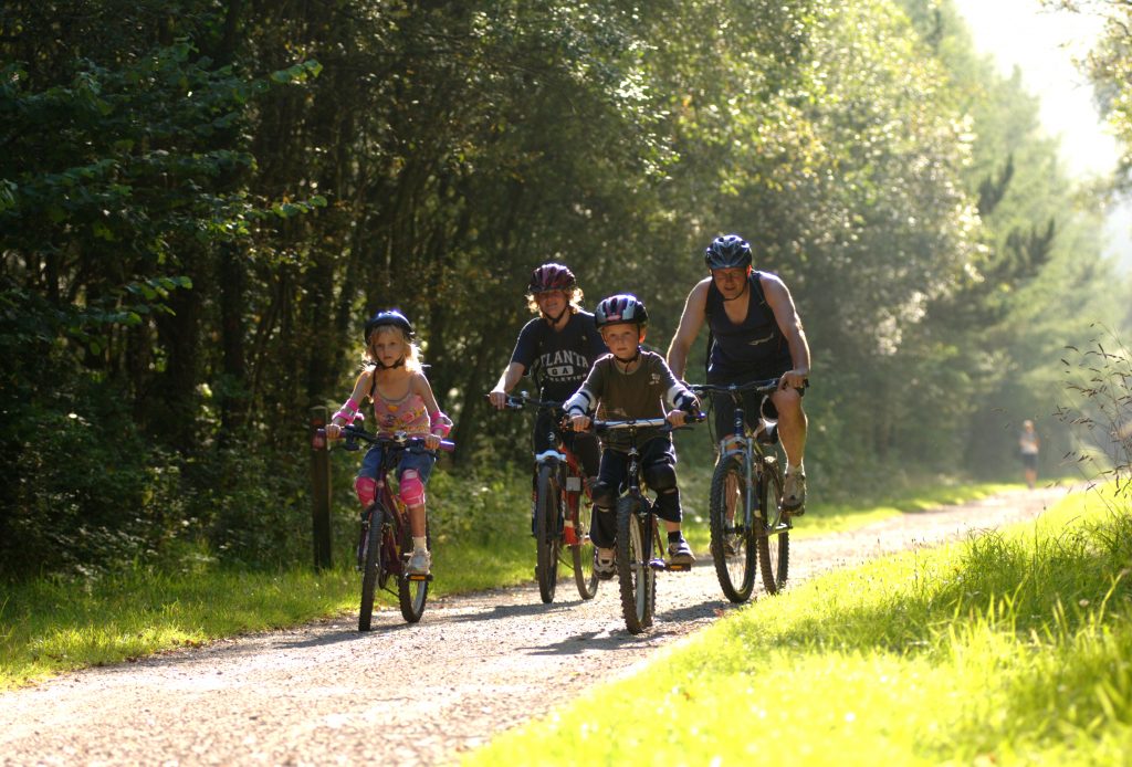
Where can we cycle ?
Our location on the hillside above the Swansea and Neath valleys dissuaded us from going far on our bikes as children and teenagers. Whilst cycling down to Pontardawe or Neath could be speedy, the return journey was not so attractive!
However with the ability to now transport bikes easily on vehicles, there are many opportunities to enjoy many miles of cycle tracks.
This route runs through Pontardawe, the route adjacent to the river Tawe in many places, chose to cycle 5 miles up the valley to Ystalyfera or go south , the 8 miles to Swansea Marina.
The stretch up the valley is a good starting point certainly with children as it is one continuous wide tarmac pathway. This stretch is seemingly flat and along the old railway track, along the base of the Swansea valley. The native trees of the wooded valley slope have become well established in the 50 or so years since the steam trains ended and create a shady canopy for many miles. It can be a cool, even damp path to ride and the sun does not easily reach the lush, leafy embankments.
Pontardawe – Swansea
The section of Sustrans route 43 that goes from Pontardawe down the valley to Swansea is a more varied topography, following the remnants of the old Swansea valley canal , avoiding the busy M4 roundabout and on to Swansea and the Marina. It is about 8 miles in length and more varied, but maybe not as pleasurable to ride as a family maybe due to a narrower path width and vying for space with pedestrians in places.
The cycle track runs all around Swansea Bay, all of 6-7 miles, hugging the coastline with fabulous sea views. However this section is extremely popular with cyclists sharing a pathway with walkers and runners. Although a line demarks the different path side for cyclists and walkers, add in fast, experienced cyclists to young families on bikes or on foot plus pedestrians and dogs on leads and it is sometimes not so relaxing or safe!
A spur from Blackpill on the central curve of Swansea Bay follows the path of the Clyne river and through Clyne valley Country Park. This is a pretty trail of about 4 miles that follows the route of the old rail network and now is part of the Celtic Trail, Route 4 of the National Cycle network. There is a steady climb of approx 90 metres to the middle point at Dunvant.
Experienced cyclists can continue on after Gowerton, using minor lanes before crossing the Loughor Bridge and then onto the traffic free section near to the Wildfowl and Wetlands Centre and on to the North Dock scenic section around the coastline.
Following a mixture of stunning coastline and beautiful woodland, the Millennium Coastal Park is rich in wildlife and history and is one of the most spectacular sections of the Celtic Trail.
Starting at the Discovery Centre in Llanelli, (or seasoned cyclists tell me they park on the street at nearby Bynea) this gorgeous 4-5 mile route winds through the site of the old Duport Steelworks, which is now the picturesque Sandy Water Park with its impressive lake and birdlife.
Continue through Ashpit Ponds Nature Reserve and the new marina at Burry Port before reaching the Pembrey Forest – one of Britain’s rare sand dune forests and home to much rare botanical wildlife including 35 species of butterfly, migrant songbirds and birds of prey! Here you’ll find a variety of fantastic tracks to follow around the country park all with varying levels of difficulty. You can also extend your adventure westward to Kidwelly, where a visit to its mighty castle is a must!
To extend your journey, follow the trail east from the Discovery Centre in Llanelli to the Wildfowl & Wetlands Centre, Loughor Bridge and onwards to Mumbles where the route joins up with Swansea Bike Path.
Route 47 Swiss valley – Cross hands
Starting at Sandy Water Park and following yet another disused railway line inland Route 47 climbs gently into the rolling hills of Carmathenshire, passing the peaceful Lliedi Reservoirs and onto Cross Hands.
There is a cycle route of some 7 miles travelling north from the seafront at Aberavon. Once beyond the bus and train station then the shopping centre the cycle track develops into a pretty woodland riverside path.
This is yet another location where the cycle path has developed along the route of a disused railway track, so links the once mining communities of Cwmafan, Pontrhydyfen and Cymmer. The trail runs along the base of the valley with convenient starting points at the Afan Forrest Park visitor centre, the Rhyslyn car park or the Glyncorrwg Mountain Bike Centre.